


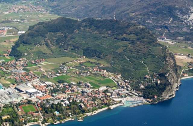
The Nordic Walking Park in Brenzone sul Garda is a network of trails dedicated to Nordic walking and hiking, with over 20 km of marked trails between the lake and the foothills of Monte Baldo. A perfectly equipped area for those who want to walk in a Mediterranean environment with a constant view of Lake Garda.
The routes
The park offers several loops of varying length and difficulty, all interconnected to allow for customised combinations. The trails wind through olive groves, lemon groves, fishing villages and small Romanesque churches, with the lake always present as a backdrop. The total difference in altitude of 300 metres is distributed over gentle trails, without any challenging climbs.
The hamlets of Brenzone – Castelletto, Magugnano, Porto, Assenza – are little jewels of lakeside architecture that the path crosses, offering a new panoramic view of the lake and the island of Trimelone off the lake at every step.
Nordic walking and wellness
Nordic walking is a complete discipline that involves 90% of the body’s muscles through the use of poles. The routes in the park are certified and mapped with distance, altitude difference and time. Local instructors offer lessons and pole hire for those who want to try it out.
Practical tips
Trails suitable for all levels. Dogs allowed on a leash. The full 20 km route takes about 3 hours, but shorter loops (3 to 10 km) can be chosen. Light trekking shoes or trainers. Along the trails, several beaches offer the possibility of a refreshing dip. Traversable all year round thanks to Brenzone’s mild microclimate.
Characteristics
Directions
The Brenzone Nordic Walking Park offers a network of marked trails of varying difficulty among the olive groves of the Verona shore. The trails start from the center of Brenzone and gradually climb towards the inland areas.
The routes are classified by color (green, blue, red) based on difficulty and length. All trails offer scenic views of the lake.
How to get there
By car: reach Brenzone from the SS249. From Verona approximately 45 minutes. By public transport: bus from Verona or Garda.
Where to park
Parking in Brenzone sul Garda, along the lake road.
Starting point coordinates
Recommended gear
Nordic walking poles (rental available at the tourist office). Sneakers or light trekking shoes. Water, sunscreen.
Safety
Safe and well-marked trails. Suitable for all fitness levels. Choose the route based on your abilities. In summer bring plenty of water.
Loading forecast...

Need help planning?
Our AI assistant knows every trail around Lake Garda.
 Ask about this route...


