

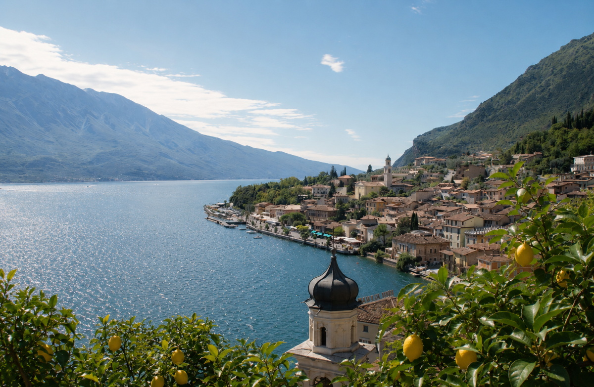
Amidst terraces of centuries-old lemon groves and breathtaking views of the lake, the Sentiero dei Limoni is a walk that tells the agricultural history of Limone sul Garda in every metre.
Since the 13th century, these dry terraces have been home to the cultivation of lemons, protected in winter by temporary greenhouses that still dot the landscape. The name of the village actually derives not from citrus fruits but from the Latin word limes, which indicated the border of the Republic of Venice – a detail that adds historical charm to an already enchanting route.
The route
It starts at the old harbour of Limone and climbs gently between the historic lemon houses, with their characteristic dry stone walls and stone columns. The trail passes through the Limonaia, where it is possible to admire the old cultivation structures still in working order, and continues to the Calchèra belvedere, a vantage point offering a spectacular view of the lake and surrounding mountains.
The loop trail then leads back to the village centre through narrow streets and stairways, offering picturesque corners and the opportunity to stop at one of the refreshment points along the way.
A path for everyone
The difficulty is moderate and the modest height difference makes this walk ideal for families and those who want to enjoy the lake at a leisurely pace. In spring, when the lemons are in blossom, the scent accompanies the entire walk.
Characteristics
Directions
Starting from the old port of Limone sul Garda (Via Porto), you climb along the staircases that lead to the terraces of the historic lemon groves. The route is marked and passes by the Limonaia del Castèl.
You continue uphill between the dry stone walls of the ancient lemon cultivations, reaching the viewpoint of Calchèra with panoramic views over the lake. The path continues with a gentle climb to the highest point of the route.
The descent is along an alternative path that brings you back to the historic center of Limone, closing the loop.
How to get there
By car: from the SS45bis that runs along the lake, exit at Limone sul Garda. In summer, traffic can be heavy.
By public transport: Limone is reachable by ferry from Riva del Garda, Malcesine and other lake centers (Navigarda service). Alternatively, buses from Riva del Garda or Salò.
Where to park
Paid parking near Limone port. In summer it is advisable to arrive early or use the ferry to avoid traffic. Parking coordinates: 45.824433, 10.812414.
Starting point coordinates
Recommended gear
Comfortable shoes with non-slip soles (there are stone staircases). Water, sunscreen and hat. In spring a light jacket for shaded sections.
Safety
Some sections of the trail have steep staircases and can be slippery after rain. Be careful of unprotected edges of the terraces. Trail suitable for families with children accustomed to walking.
Loading forecast...
Need help planning?
Our AI assistant knows every trail around Lake Garda.
 Ask about this route...


